Posted in Fun

Whiling Away In the Chesapeake Bay

Sailing on the Patuxent River, MD

After a wonderful (albeit soggy) visit to Gettysburg, PA, we were ready for some sun, sand, and seafood, so we towed Gracey to Solomon’s Island, MD in the Patuxent River area of the Chesapeake Bay. We visited Solomon’s three years ago on our trip up the East Coast and fell in love with it. We eagerly looked forward to returning.

Originally, we reserved four nights at the Navy Recreation Center on Solomon’s Island, but we received a call that the campground office at Ft. Story, VA, our next stop, canceled our reservations there due to the threat of Hurricane Florence. As a result, we extended our stay at Solomon’s for three additional nights until we could figure out where to go next. We were content to remain…it was time to dry out in the sun, and a few extra days in one spot meant that we could slow the pace a bit (as if we could get any slower).

Dry Dock, Solomon’s Island, MD

Once we moved Gracey into her home for the week and got settled, we made the five-minute drive into the charming village of Solomon’s Island and the Dry Dock restaurant. Thankfully, the Dry Dock crowd was light when we arrived so we could sit on the deck overlooking the Marina and the Patuxent River. Immediately, we placed an order for a dozen raw oysters and devoured them as quickly as they arrived at our table.  For dinner, I ordered a creamy fettuccine dish smothered in freshly grilled shrimp that lasted about as long as the oysters. Helen (adorable wife) hit the jackpot with the Signature Scallop And Crab Bake of perfectly seasoned baked crab, dusted with Panko flakes and topped with seared scallops. The dish featured sides of apple arugula slaw, seasonal vegetable and a small cup of caper dill tartar sauce. In plain words, this meal was a bowl full of baked fresh crab and scallops. She still talks about it.

Point Lookout State Park, MD

Helen has a cousin stationed at nearby Patuxent River NAS, and we enjoyed a delightful visit with him and his family one evening in their home.  Lt. Commander DB and Bonnie were a big help in providing suggestions for daytime activities and areas to explore. One suggestion was Point Lookout State Park about 35 miles away.  After breakfast one morning, we pointed Bert south to the tip of the peninsula where the Potomac River enters into the Chesapeake Bay. The day was bright and sunny. It was hard to believe that a hurricane was causing a ruckus anywhere near us.

Hooked a big stingray

Point Lookout is a very scenic area and features a lighthouse overlooking the Bay.  On this day, we saw no one except for a few folks fishing from the pier.  We watched them reel in a very stubborn Sting Ray. While in the park, Helen and I did some leisurely beach walking then enjoyed a ride back to Gracey through the Maryland coastland.

Big Fun at the Ruddy Duck
Ruddy Duck patrons

On another evening, we decided to have drinks and dinner at the Ruddy Duck located just a short drive from the campground.  This restaurant and lounge received the number one spot on Trip Advisor, and we felt obligated to check it out. We happened to arrive on the night that the restaurant chose to observe a six-month countdown to St. Patrick’s Day.  We had a very difficult time procuring seats but finally found two near some over-served Irish guests wearing bright green shirts. In one corner, a one-man band was playing Irish folk songs on a variety of instruments, most notably a lively fiddle. We ordered some pub food, then joined right in and had a great time.

DB and Bonnie also recommended Flag Ponds Nature Park as a great spot to hunt shark’s teeth, a favorite activity of ours.  We arrived on a somewhat cloudy day.  Although the park charges admission, there were no attendants at the gate.  We drove on. From 1905 to 1955, Flag Ponds housed fisherman who lived in three shanties during fishing season. They trapped fish in large nets and sold them in markets as far away as Baltimore.  Once fishing methods became more sophisticated, and labor costs increased, the activity ceased at Flag Ponds.  A replica of a fishing shanty remains on the old site.

Searching for shark’s teeth

Despite giving it our best efforts, we did not find any shark’s teeth on this day.  We observed a group of school children working a small pond to catch small fish and take them to a naturalist to identify.  The children seemed totally engrossed in the activity, and it seemed obvious that learning was taking place.

A couple of days before our Solomon’s stay ended, Helen placed a call to Fort Story to inquire about our reservations. Although Hurricane Florence had wreaked havoc in North Carolina, she spared Virginia, and we felt there was a chance that the campground had reopened. Luck was with us, and we obtained reservations for three nights.

Cabin, MWR Solomon’s Island
The campground, MWR Solomon’s Island

Before we left the Island, I wanted to share some information with our Military friends because this is a great place to enjoy a family vacation. In addition to the campground, NRC Solomon’s Island offers cozy cabins with screen porches, a large marina with boats for rent, as well as several playgrounds and fishing piers. There is plenty to do in the area, and Patuxent River Navy Base features a large Commissary and Exchange. We recommend it highly.

Marina, MWR Solomon’s Island

We have traveled a lot in the three years since we retired and visited many interesting and beautiful places. I would put Solomon’s Island in the top five for sure and, given the time to think about it, perhaps even higher. Sun, sand, and seafood is an unbeatable combo, but it’s time to be Easin’ Along.

Posted in Fun

The Roads Led Them to Gettysburg

General Warren on Little Round Top

They came to Gettysburg because the roads led them there. In July 1863 Gettysburg was much like it is today. Rows of houses dotted the hillsides. Farms and fields stood lush green in color. Cows and horses grazed lazily in roadside pastures.  Fences and barns were in good repair.

Gettysburg, PA, 1863

Confederate General Robert E. Lee led his Army of Northern Virginia with 70,000 men northward after the battle of Chancellorsville. Lee hoped to restock his Army with much-needed food and supplies and perhaps draw some of the Union Forces into the area and away from campaigns in the south. The roads led him to Gettysburg.

Lee’s cavalry, under the command of General J.E.B. Stuart, was on a scouting run. Therefore Lee had no idea that The Army of the Potomac, some 93,000 men strong commanded by General George Meade were nearby. Over the next three days, these two armies collided in the fiercest battle ever fought on the North American continent, and the result ultimately decided whether there would be one nation or two between Canada and the Rio Grande. It all happened because the roads led them to Gettysburg.

Helen (adorable wife) and I came to Gettysburg under much less ominous circumstances. We came from Front Royal, Virginia and, while the road led us to Gettysburg, we intended to go there and spend some time exploring the area as well as the Gettysburg National Military Park. We had a reservation at the Gettysburg Campground for four nights. Robert, the owner of the campground, met us when we arrived. He immediately noticed the University of Tennessee decal on the window of Bert (truck) and proudly introduced himself as an alum of our great university. We knew we liked him.

After getting Gracey (trailer) settled into a cozy campsite with a wide stream to our rear, we drove the short distance into town to pick up our dinner for the evening at Tommy’s Pizza. The drive took us alongside the battlefield.  We couldn’t help but note that this was hallowed ground. Our pizza was extraordinary, and we ate while we watched television inside Gracey–the first and only time we would stay in a campsite with cable television on our trip. Outside our trailer, rain fell in buckets.

Rising stream

The next morning we took advantage of the clean and spacious showers in the campground.  While there, Helen learned from another camper that the overnight rainfall had dumped three and a half inches of rain on us with more on the way. When we returned to Gracey, a gentleman from the campground came to tell us that the campground was closing because of the fear of flooding from the stream behind us. We were forced to move to another campground on Artillery Ridge adjacent to the battlefield and higher ground. We hated to leave because Gettysburg Campground is very, very nice.

The next morning we signed up for a Battlefield tour. The rain continued, but we decided to make the best of it.  I was eager to take the tour.  Many years ago I visited Gettysburg while on duty as an Army Reservist at nearby Indiantown Gap, PA. That visit was short, but I learned enough to know I had to return.

Battlefield tour

Despite the rain, the Visitor Center and Museum in the National Park was a hub of activity.  Helen and I watched a film that gave an overview of the three days of fighting and visited the cyclorama featuring a huge artistic depiction of day three of the battle. After that, we boarded a bus full of civil war buffs.  The tour guide joined us after everyone was seated and introduced himself.  He appeared to be close to my age and gave a great opening presentation of what we were about to see.  Everyone was asked to tell us what state they called home.  Helen and I were the only Tennesseans. Most of the crowd were Northerners…I immediately let them know I held no grudges.

Tennessee Monument – Seminary Ridge

The bus tour began on Seminary Ridge where General Lee formed his Army to begin the final day’s battle. Although the day was gloomy, we could see Cemetary Hill where the Union Forces gathered a mile away. I took a moment to photograph the monument dedicated to the Army of Tennessee.

Once we left Seminary Ridge, we visited all of the prominent sites of the battlefield including the Peach Orchard, Little Round Top, Devil’s Den, Valley of Death, The Codori Farm, and the Copse of Trees that served as the focal point for Pickett’s Charge. We made our way to Cemetary Hill and the stone wall that was pierced by only one Confederate officer and marked the final moments of the battle.

Copse of Trees

Our group looked back across the battlefield toward Seminary Ridge as the tour guide narrated the advance of 12,000 men led by Brigadier General George Pickett across the mile-long open field facing withering rifle fire and canister rounds. That march of Confederates cost Lee 5,000 men in an hour. Those who survived were turned back as the Union soldiers yelled out in the victory. Signs near the stone wall noted that, after three days of fighting, the total number of casualties numbered over 50,000 men killed, wounded, or captured. I was exhausted, and all I did was ride on a bus.

Day three – Near the end of the battle

The Civil War would go on for almost two years beyond Gettysburg. However, this battle marked the “High Water Mark” for the Confederacy. As everyone knows, the Union would ultimately prevail. Portions of the battlefield at Gettysburg became a National Cemetary dedicated to the brave men that fought and died there and later commemorated by President Lincoln in his historic address.

Battlefield from Cemetery Hill

Our visit to the battlefield on a rain-soaked day added to the somber feel that surrounds it.  Nevertheless, I consider it an honor to walk those hallowed grounds, and I’m grateful that the roads led us there.

Posted in Fun

Moving Up the Blue Ridge…Quietly

Shenandoah Valley

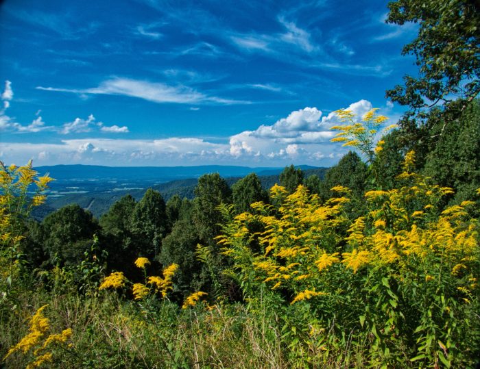
We left our campsite at Stone Mountain State Park near Roaring Gap, NC and soon crossed into Virginia. We were still on the Blue Ridge Parkway, and the overlooks continued to amaze and astound. The picture of the Shenandoah Valley (above)is a good illustration. Our destinations for the next eight nights included Horseshoe Point Recreation Area, near Henry, VA, and Bolar Mountain Recreation Area in Warm Springs, VA and close to the West Virginia border. We were about to enter the “quiet period” of our journey.

Unlike many of our RV stops which include sightseeing, flea market browsing, and sampling the local food and beverage offerings, these two visits would contain none of that…because none of that existed there. We were going into the deep woods. It was time for some solitude and, we would eat our own cooking for a few days.

Philpott Lake

Horseshoe Point is several miles off of the Parkway and adjacent to Philpott Lake. The campground is nice and offers both water and electric. The shower facility is clean and seems almost new. As it often happens, we arrived during a rainstorm which makes un-hooking setting up a real challenge, especially on a site with a few large pine trees adding to the difficulty of backing into a campsite. Nevertheless, we got it done despite the rain.

Deep cleaning

Over the next day or so, we relaxed. Helen (adorable wife) took the time to do some deep cleaning inside Gracey as well as spending time on her puzzle that is more of a challenge than she realized. I spent my time finishing up a book containing short biographies of all 425 Generals of the Confederacy. Some of those men led amazing lives, and I wanted to complete the book before we made it to Gettysburg.

Puzzle party

In addition to those vigorous activities, we ventured to nearby Fairystone State Park where I picked up one of the Fairystones found in the area. I had visited the park with my family at around age 12 and felt obligated to return. On the way back, Helen and I drove to Ferrum, VA to do our laundry and briefly browse a flea market. On our last day there, we drove to the overlook at Philpott Lake. By now, I’m confident that I have put every Easin’ Along reader to sleep but, if not, read on. By the time I take you through Bolar Mountain, you may be in a coma.

Fairystone

Bolar Mountain Recreation is an almost two-hour drive west of the Blue Ridge Parkway. We did not realize that at the time we made the reservation. It is not that far as the crow flies, but crossing the mountains along some twists and turns at 35 mph takes time. The campground is very isolated and primarily used by folks who come to fish the scenic waters of Lake Moomaw. The gentleman camped next to us comes every year for six weeks along with several of his buddies.

Mist over Moomaw
Pileated woodpecker

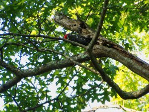
This campground is quieter than quiet. For activity, Helen and I swam in the lake, which we had to ourselves on a misty, but lovely, day. Beyond that, the most action I had was chasing a Pileated Woodpecker around the campground to take his picture. We read a lot here also. By the end of our second day, Helen said that she was ready to end our “Wilderness Experience” and that it was time to move on. It was more than boredom that prompted the decision, however. On paper, it appeared that Gettysburg was about a four-hour drive away, but with the mountains and curving roads in front of us, that trip extended to more than six hours, and we don’t do six unless we have to. We made a reservation for one night in Front Royal, VA which is at the end of a charming drive along the Virginia Skyline. The campground we booked in Gettysburg allowed us to come a day early.

L Dees – Front Royal, VA

We can’t say much for the campground, but the town of Front Royal is charming. Trip Advisor told us that we had to eat breakfast at L Dees Pancake House and, for that, we’re genuinely grateful. The small diner was filled with locals (always a good sign) and the staff was polite, efficient, and seemed to be having a great time greeting and serving all their friends who came for breakfast. Helen’s omelet was excellent, and my pancakes were the best. Outside of the restaurant and all along the street, flower baskets hung from poles, adding a touch of charm to this small town.

Street Flowers – Front Royal, VA

If you’re still with me after all of this frenzied activity, I have to let you know that, in spite of the low key nature of these past two stops, we enjoyed our time in both of them. We needed a pause and time to breathe some mountain air. What’s the hurry, we say. We’re supposed to be Easin’ Along anyway.

Next week – Gettysburg National Military Park.